

Compass

Compass介绍
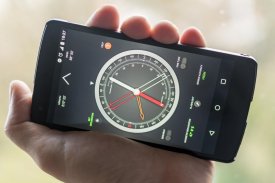
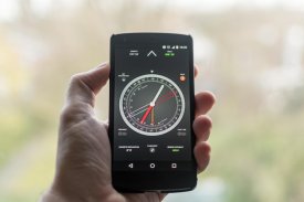
A compass is a navigation instrument with a free rotating needle that indicates the direction of magnetic north.
Most people know how to find the north using a compass. Few know how to use it as a navigation tool. The ability to navigate with a compass and a map is one of the most useful things to know while hiking. This compass app is not just a simple north direction indicator but is intended to be used as a real orientation tool for hiking activities.
Prerequisite: Your device must have an integrated compass sensor to function properly.
Highlights:
+ Orienting compass functions
+ Suitable for camping, hiking, and other outdoor activities
+ HD graphics
+ Quick step by step use guide
Features:
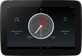
+ Rotating bezel
+ Rotating orienting arrow
+ Adjustable magnetic declination
+ Fine tune of the rotating bezel
+ Fine tune of the orienting arrow
+ Clinometer
+ Flashlight
Before you start using your compass
Each time you open the compass, shake your device a few times around its three axes in order to improve accuracy.
If your phone or tablet is protected by a magnetized cover, remove it before using the compass.
To rotate the compass bezel or orienting arrow, place two fingers on the screen at the same time and perform a rotation gesture.
Adjust the magnetic declination
1. Find the current magnetic declination for your location.
2. Push the Set Declination button.
3. Set the magnetic declination by turning the orienting arrow. You can fine tune the declination by activating the Fine Tune mode.
4. Push again the Set Declination button to block the orientation arrow.
Reset the magnetic declination
For a rapid magnetic declination reset, press and hold the Set Declination button.
Orient a map
1. Adjust the magnetic declination if necessary.
2. Rotate the bezel so that the north mark aligns with the index mark.
3. Place the device on the map so that its edge aligns with the map longitude lines.
4. Rotate the device and the map together until the magnetic needle aligns with the orientation arrow. Now your map is aligned with the geographical north.
Take a bearing from a map
1. Orient the map.
2. Place the device on the map so that its edge aligns with your current location and the location you wish to travel to.
3. Rotate the bezel until the orientation arrow aligns with the magnetic needle.
4. The direction of travel arrow on the compass gives you your direction of travel.
Find where you are on a map
1. Look around and select two distant objects that you can identify on your map.
2. Mark the selected objects on the map.
3. Orient the map.
4. Aim the direction of travel at the first object.
5. Rotate the bezel until the orientation arrow aligns with the magnetic needle.
6. Place the device on the map and draw a line along its edge through the mark of the first object.
7. Repeat from step 4 for the second object.
8. The intersection of the two obtained lines gives you your approximate position. If you repeat the process with a third object, the intersection of the three lines will result in a triangle. Your approximate position on the map is inside the triangle.
Measure the slope of the terrain
1. Rotate the bezel so that the east or west mark aligns with the index mark.
2. Place the device on the ground, aligned with the greatest slope.
3. Read the slope value shown by the clinometer needle on the inner scale of the compass.
罗盘是导航设备来与一自由旋转针指示磁北的方向。
大多数人都知道如何使用指南针找不到北。很少有人知道如何使用它作为导航工具。指南针和地图导航的能力是最有用的东西,要知道,而徒步旅行之一。该罗盘程序不只是一个简单的正北方向指示器,而是意图被用作远足活动真正的定向工具。
先决条件:您的设备必须具有一个集成的方位传感器正常工作。
强调:
+定向罗盘功能
+适用于露营,远足,和其他户外活动
+高清显卡
+快速一步一步使用导
特征:
+旋转表圈
+旋转定向箭头
+可调磁偏角
+转动框的微调
+定向箭头的微调
+倾斜仪
+手电筒
在您开始使用您的指南针
每次打开指南针时,摇动装置围绕其三个轴几次以提高精度。
如果您的手机或平板电脑被磁化盖保护,使用前指南针删除它。
在同一时间在屏幕上以旋转罗盘挡板或定向箭头,放置两个手指并执行旋转手势。
调整磁偏角
1.查找您所在地区的目前的磁偏角。
2.按下设置按钮衰落。
3.通过转动定向箭头设置磁偏角。您可以通过激活微调模式微调偏角。
4.再次按下设置按钮衰落阻断方向箭头。
重置磁偏角
对于一个快速磁偏角复位,按住设置赤纬按钮。
定向地图
1.如果需要,调整磁偏角。
2.旋转挡板,使得北标与索引标记对齐。
3.将地图上的装置,使得它的边缘与地图经度线对齐。
4.旋转装置与所述地图一起,直到磁针与取向箭头对齐。现在,您的地图与地理北一致。
从地图采取的轴承
1.东方地图。
2.将地图上的设备,以便其边缘与您当前的位置和你想前往的位置对齐。
3.旋转挡板,直到方向箭头与磁针对齐。
4.指南针旅行箭头的方向向你行进方向。
找到你是地图上的位置
1.环顾四周,并选择你能找出你的地图上的两个远处的物体。
2.标记在地图上所选的对象。
3.东方地图。
4.在第一对象对准行进方向。
5.旋转挡板,直到定向箭头与磁针对齐。
6.将地图上的设备,并通过第一物体的标记绘制沿其边缘的线。
7.从所述第二对象的步骤4重复。
8.得到的两个条线的交点为您提供您的大概位置。如果重复此过程的第三个目的,三线的交叉将导致一个三角形。您在地图上的大概位置是在三角形内。
测量地形坡度
1.旋转挡板,使得东或西标记与索引标记对齐。
2.将地面上的装置,以最大的斜率对齐。
3.读取由测角器针上的罗盘的内刻度示出的坡度值。


